Few drives on earth rival the drama of California’s Highway 1. Carved directly into sheer granite sea cliffs above the churning Pacific Ocean, this ribbon of asphalt stretches past misty redwood canyons, hidden sea caves, historic lighthouses, and sun-drenched coastal bluffs. Whether you are driving a vintage roadster or an expedition-ready camper, conquering the Pacific Coast Highway remains the quintessential American road trip.
The best 5-day Pacific Coast Highway road trip covers roughly 470 miles from San Francisco to Los Angeles, driving south to north or north to south. Always drive southbound so your vehicle rides the ocean side of the road, giving you effortless access to cliffside pullouts and unobstructed coastal panoramas. Key overnight hubs include Santa Cruz, Monterey, San Simeon or Cambria, and Santa Barbara. For live slide repairs and bypass routing around Big Sur, always check Caltrans QuickMap live highway updates before you turn the ignition.
Road trip essentials at a glance
- ✓
Drive Southbound: Heading south puts passenger seats directly on the ocean side with safer right turns into scenic viewpoints. - ✓
Plan Fuel Around Big Sur: Gas stations in Big Sur charge up to double standard rates. Top off in Carmel or Morro Bay before entering the wilderness corridor. - ✓
Reserve State Parks Early: High-demand coastal gems like Point Lobos and Julia Pfeiffer Burns fill parking lots by 9:00 AM during peak summer and fall weekends.
The 5-Day Route Plan at a Glance
Trying to tackle Highway 1 in 48 hours turns a bucket-list expedition into a blur of brake lights and white-knuckle driving. Distances on paper look deceivingly short, but narrow two-lane pavement, 25 mph hairpins, and slow-moving RVs mean your average travel speed hovers around 35 miles per hour. Five days strikes the sweet spot, allowing you to hike coastal headlands, sample fresh oyster shacks, and watch sunsets from cliffside perches without rushing.
| Day | Route Segment | Distance & Drive Time | Overnight Hub | Key Route Highlights |
|---|---|---|---|---|
| Day 1 | San Francisco to Santa Cruz | 75 Miles (2.5 Hours) | Santa Cruz or Capitola | Pacifica, Pigeon Point Light, Shark Fin Cove |
| Day 2 | Santa Cruz to Monterey & Carmel | 45 Miles (1.5 Hours) | Monterey or Carmel-by-the-Sea | Monterey Bay, 17-Mile Drive, Point Lobos |
| Day 3 | Big Sur Coastline Exploration | 65 Miles (3.5 Hours) | Big Sur Village or Cambria | Garrapata, Bixby Bridge, Pfeiffer Beach, McWay Falls |
| Day 4 | San Simeon to Pismo Beach | 95 Miles (2.5 Hours) | San Luis Obispo or Pismo Beach | Elephant Seal Rookery, Hearst Castle, Morro Rock |
| Day 5 | Santa Barbara to Los Angeles | 130 Miles (3.5 Hours) | Santa Monica or Malibu | Stearns Wharf, Gaviota Coast, El Matador, Malibu Pier |
Explore our library of curated scenic road trip itineraries for additional regional routes and seasonal packing tips before hitting the highway.
The 15 Best Pacific Coast Highway Stops
1. Pacifica State Beach and Devil’s Slide Coastal Trail
Departing south from San Francisco on Highway 1, Pacifica is your first taste of rugged coastal topography. The crescent-shaped bay attracts cold-water surfers year round, but the real highlight sits just two miles south at Devil’s Slide. Formerly the most treacherous stretch of road in Northern California, this 1.3-mile retired roadway has been converted into a paved pedestrian and cycling trail perched hundreds of feet above churning whitecaps.
Walking the Devil’s Slide Trail gives you an intimate look at sheer sea cliffs without vehicular traffic humming beside your shoulder. Keep binoculars handy: common murres nest on the rocky offshore sea stacks, and gray whales pass close to the bluffs during winter and spring migration.
2. Half Moon Bay and Mavericks Beach
Half Moon Bay balances working fishing-harbor grit with sweeping pumpkin-patch coastal fields. Pillar Point Harbor shelters California sea lions barking from the docks, while a short walk along the coastal marsh brings you to Mavericks. During massive winter swells generated by North Pacific storms, this reef break produces legendary 50-foot waves that draw the world’s most daring big-wave surfers.
Even on calm summer afternoons, the Pillar Point bluff trail provides wide views across the marine reserve. Pick up fresh local dungeness crab or rockfish straight from commercial fishing boats docked at Johnson Pier before heading down to Pescadero.
3. Pigeon Point Light Station State Historic Park
Rising 115 feet above the rocky Pescadero shoreline, Pigeon Point is one of the tallest lighthouses in the United States. In service since 1872, its historic Fresnel lens once guided ships navigating through dense coastal fog banks that routinely blind the coastline.
While the main brick lighthouse tower undergoes preservation work, the surrounding grounds, visitor center, and cliffside boardwalks remain open to visitors. The wooden observation decks extend out over wave-battered tide pools where harbor seals haul out on exposed rock platforms at low tide.
4. Shark Fin Cove (Davenport)
Tucked just off the highway two miles south of the tiny town of Davenport, Shark Fin Cove is named for the towering offshore sea stack that looks identical to a prehistoric shark fin breaking the surface. The steep dirt path leading down to the sand requires careful footing, especially after wet coastal mornings.
At the back of the pocket beach sits a deep sea cave hollowed out by centuries of relentless wave action. Arrive during morning low tide to explore the cave interior, but keep an eye on the ocean swell: rogue waves can surge up the beach rapidly.
5. Santa Cruz West Cliff Drive and Natural Bridges
Santa Cruz brings a relaxed surf culture energy to Day 1. Instead of sitting in boardwalk traffic, head directly to West Cliff Drive. This scenic three-mile pedestrian path traces the bluffs from the Santa Cruz Surfing Museum inside the historic Mark Abbott Memorial Lighthouse down to Natural Bridges State Beach.
At Steamer Lane, watch local surfers carve cold-water rights against the sandstone cliffs. Continue west to Natural Bridges to view the mudstone sea arch and visit the eucalyptus grove, which shelters thousands of migrating monarch butterflies between October and January.
6. Monterey Bay Coastal Recreation Trail and Old Fisherman’s Wharf
Cruising across the fertile artichoke fields of Castroville delivers you to Monterey Bay. Protected under the federally designated Monterey Bay National Marine Sanctuary, this submarine canyon supports sea otters, harbor seals, and feeding humpback whales just yards from shore.
Rent a bicycle or lace up your walking shoes to explore the paved Coastal Recreation Trail. It links Cannery Row, made famous by John Steinbeck, to the historic working docks of Old Fisherman’s Wharf, where clam chowder bread bowls and espresso stands fuel early-morning harbor watching.
7. 17-Mile Drive and The Lone Cypress (Pebble Beach)
Connecting Pacific Grove to Carmel, the gated 17-Mile Drive winds through the Del Monte Forest and along the wind-sculpted granite coastline of the Monterey Peninsula. While there is a modest vehicle entry toll, the coastal views justify every cent.
The star landmark is the Lone Cypress, a solitary Monterey cypress clinging to a wave-battered granite rock for over 250 years. Further south, pull over at Spanish Bay to listen to the ocean surf and see sea birds foraging in tidal kelp beds.
8. Point Lobos State Natural Reserve
Landscape artist Francis McComas famously declared Point Lobos “the greatest meeting of land and water in the world,” and few who walk its coastal trails disagree. Protected under the oversight of the California State Parks Point Lobos Reserve, this promontory showcases virgin Monterey cypress groves, jade-colored coves, and active sea otter nurseries.
Lace up your hiking boots for the Cypress Grove Trail and Bird Island Trail. You will walk through ancient lace lichen draped across twisted trees, look down into China Cove where sea otter pups nap wrapped in bull kelp, and listen to the rhythmic barking of sea lions echoing from offshore rocks. Review our field-tested coastal hiking trails to plan footwear and pacing.
9. Garrapata State Park and Calla Lily Valley
As you pass the Carmel Highlands, the Santa Lucia Mountains crash directly into the sea, marking the official northern gateway to Big Sur. Garrapata State Park remains remarkably wild, with miles of windswept coastal bluff paths free from commercial development.
Between late January and April, follow the unmarked trail down from Highway 1 mile marker 63 into Darsena Ravine, affectionately known as Calla Lily Valley. Hundreds of pristine white wild calla lilies bloom along a freshwater creek that empties directly onto Garrapata Beach against a backdrop of charging Pacific breakers.
10. Bixby Creek Bridge (Big Sur)
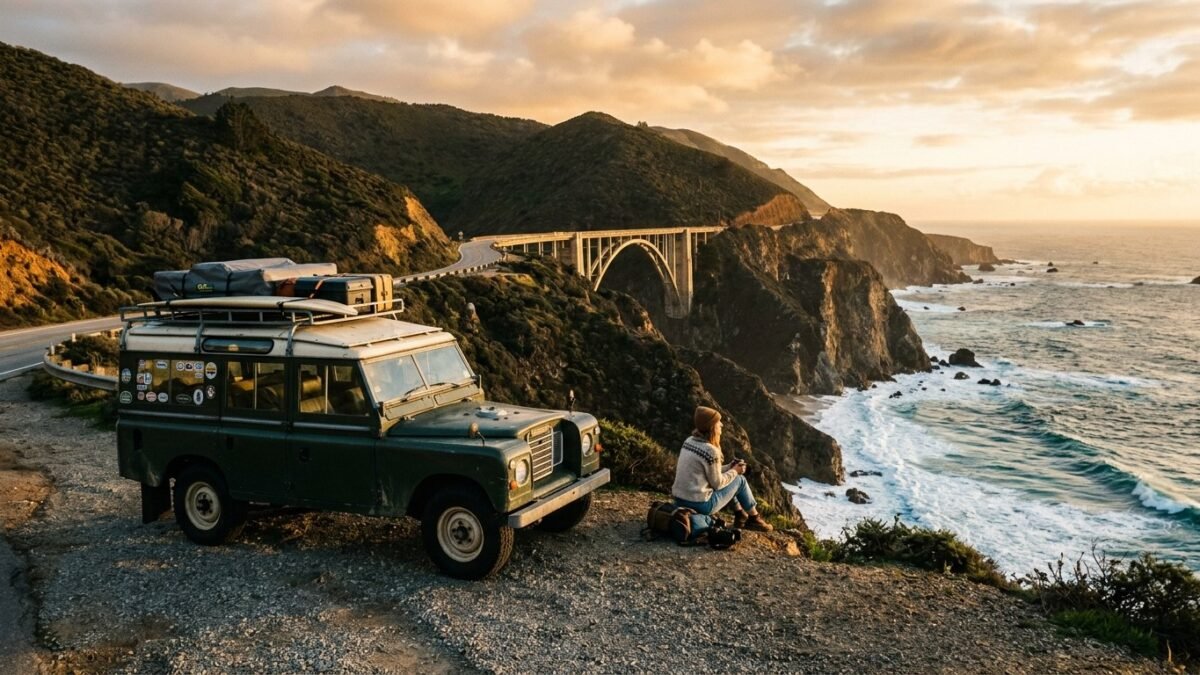
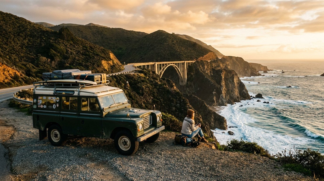
Bixby Creek Bridge is one of the most photographed engineering marvels on earth. Completed in 1932 for just over $200,000, this graceful concrete open-spandrel arch spans 320 feet across a dramatic canyon 260 feet above the ocean floor.
Pull into the dirt turnout on the inland northwest side of the highway for the classic viewpoint looking south toward the arch and the winding road beyond. Arrive during early morning or late golden hour when the low sun illuminates the western face of the concrete pillars.
11. Pfeiffer Beach and Keyhole Rock
Pfeiffer Beach does not appear on ordinary highway signs. Finding it requires watching for unmarked Sycamore Canyon Road south of Big Sur Village, then following a narrow, single-lane paved road two miles down through redwoods to the coast.
The reward is a dramatic beach famous for its purple garnet sand streaks and Keyhole Rock. During winter solstice weeks in late December and early January, the setting sun aligns precisely through the natural arch at low tide, projecting a blazing beam of golden light through the breaking surf.
12. McWay Falls at Julia Pfeiffer Burns State Park
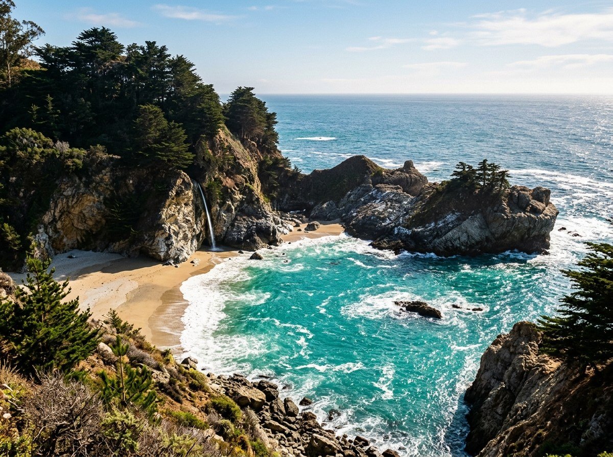
McWay Falls is one of only two tidefalls in California, waterfalls that pour directly into the ocean or onto untouched beach sand depending on the tide. Fed by McWay Creek, this 80-foot silver plume drops over granite cliffs into the emerald waters of McWay Cove.
The short, wheelchair-accessible waterfall overlook trail leads from the park parking lot through a pedestrian tunnel under Highway 1 to panoramic cliffside platforms. Do not attempt to climb down into the cove: the decomposing granite cliffs are dangerously unstable, and trespassing citations carry hefty fines to protect the delicate marine sanctuary.
13. Piedras Blancas Elephant Seal Rookery (San Simeon)
As Highway 1 flattens out onto the coastal plains of northern San Luis Obispo County, a pungent ocean aroma and deep guttural bellows signal your arrival at Piedras Blancas. This protected shoreline is home to a colony of over 25,000 northern elephant seals.
A network of wooden boardwalks allows you to safely observe these massive marine mammals from just a few yards away without disturbing them. Bull seals weighing up to 5,000 pounds battle for territory during the winter breeding season from December through February, while spring and summer bring molting seals and playful pups sleeping on the sand.
14. Morro Rock and Harbor (Morro Bay)
Known as the “Gibraltar of the Pacific,” Morro Rock is a 576-foot volcanic plug formed 23 million years ago. It stands sentinel over the entrance to Morro Bay Harbor, surrounded by salt marshes and sand spits that host resting brown pelicans, cormorants, and rare peregrine falcons.
Park at the base of the rock to watch sea otters floating on their backs cracking clams with stones, then head along the Embarcadero for local fish tacos. The protected bay waters make this one of the premier sea kayaking locations on the Central Coast.
15. El Matador State Beach (Malibu)
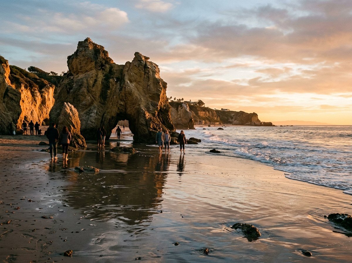
Leaving Santa Barbara and the agricultural valleys of Oxnard behind, Highway 1 traces the dramatic foot of the Santa Monica Mountains into Malibu. Among Malibu’s trio of Robert H. Meyer Memorial Beaches, El Matador stands out for its towering sea stacks, natural rock arches, and dramatic tidal caves.
Descend the steep staircases built into the canyon bluff to reach the shoreline. At low tide, you can walk straight through natural rock arches while Pacific swells foam around your ankles, catching sunset light that turns the water into liquid amber before your final arrival into Los Angeles.
Essential Field Gear and Road Trip Packing List
Coastal California microclimates mean you can experience 52-degree maritime fog and 85-degree blazing sunshine within forty minutes of driving. The right layering strategy keeps you comfortable on wind-swept bluffs. Check out our tested road trip gear essentials for detailed reviews.
- Breathable Windbreaker or Shell: Coastal headwinds along Big Sur and Point Lobos are relentless. A packable nylon wind shell protects against ocean spray without causing you to overheat during steep climbs.
- Polarized Sunglasses: Glare reflecting off the Pacific can cause severe eye fatigue during hours of southbound afternoon driving. Polarized lenses are critical for spotting marine life beneath the water’s surface.
- Compact Binoculars: A pair of 8×42 or 10×42 optics transforms your road trip. You will use them daily to spot gray whale spouts, sea otter rafts, and nesting raptors on distant sea stacks.
- Offline Mapping App: Cellular reception cuts out completely for 45 miles between Carmel Highlands and Ragged Point. Download offline maps on Google Maps or Gaia GPS before leaving Monterey.
Frequently Asked Questions
Is Highway 1 through Big Sur fully open in 2026?
Highway 1 in Big Sur is susceptible to winter landslides following atmospheric river storms. Caltrans continues active road reinforcement and repair work at historical slide zones like Regent’s Slide and Paul’s Slide. Always verify active conditions on the Caltrans QuickMap website or mobile app before your trip so you can use Highway 101 and Route 46 as a scenic inland bypass if temporary closures occur.
Which direction is best to drive the Pacific Coast Highway?
Driving north to south (San Francisco to Los Angeles) is the superior direction. Southbound travel puts your vehicle on the ocean side of the road, giving passengers uninterrupted coastal views and simple, safe right turns into cliffside viewpoints without crossing oncoming traffic.
How much does fuel cost along the Pacific Coast Highway?
Gas stations in Big Sur (near Gorda and Big Sur Village) routinely charge $8.00 to $10.00 per gallon because of remote delivery logistics. You can save substantial cash by filling your gas tank completely in Monterey or Carmel before heading south, which easily provides enough range to reach regular-priced gas stations in Cambria or Morro Bay.
What is the best time of year for a PCH road trip?
September through November offers the finest road trip weather along Highway 1. Summer months often bring “June Gloom,” with dense coastal fog obscuring ocean views until early afternoon. Autumn brings clear blue skies, warmer ocean breezes, minimal rainfall, and significantly thinner tourist crowds along popular trailheads.
The Final Trailhead Verdict
The Pacific Coast Highway is more than just a transportation corridor between Northern and Southern California; it is an expedition through some of the most dramatic coastal wilderness in North America. Take your time, pack your layers, honor the speed limits along narrow clifftops, and pull over often to watch the Pacific tide shape the edge of the continent. Start mapping your stops, reserve your Monterey and Cambria lodging early, and prepare for an unforgettable five days on the open road.