Blog
Tongariro Alpine Crossing

After nearly two weeks driving the circumference of the South Island (again), Emmett and I had taken our car on the ferry to Wellington. We drove around a bit on the North Island before making our way back up to Auckland to reunite with C.J. But it wasn’t just a reunion we had planned – after a little over 24 hours in Auckland, the three of us headed down to the lakeside town of Taupo so that we could hike the Tongariro Alpine Crossing together.
The Tongariro Alpine Crossing is arguably one of New Zealand’s most popular hikes. The Crossing is a 19.4 kilometer (12.1 mile) walk through active volcanic terrain in World Heritage-listed Tonagriro National Park. According to a NZ Department of Conservation (DOC) worker who we spoke to later that day, the track is most popular in the summertime when there can be upwards of hundreds of hikers attempting the crossing each day. I was stunned to hear it because the Alpine Crossing was not an easy hike by any means. In fact, it was not only very long for a “day hike” but it was also quite strenuous – but more on that later.
There was a biting chill to the air that morning in Taupo. That fact, that it was cold, was one of the only thoughts that the three of us could verbalize after waking up at 5:30 A.M. As we started our hour and a half drive to the track’s start at Mangatepopo Car Park, there was a low-hanging spooky fog on the trees outside. We had picked that particular day to do the Crossing solely because the forecast had called for clear skies – for once. I have said it before and I will say it even one more time, to access any of New Zealand’s native abundance of fantastic scenery, you are at the mercy of some very fickle weather patterns. Something to do with being an island over 4,000 km from the nearest land mass… Anyway, this was actually the second time that Emmett and I had been to Taupo. We had visited for a few days last September shortly after first arriving in New Zealand and had been interested in Tongariro but had, of course, been thwarted by the weather. Anyway, the initial fog made us concerned that our visibility on the mountain would be similar.
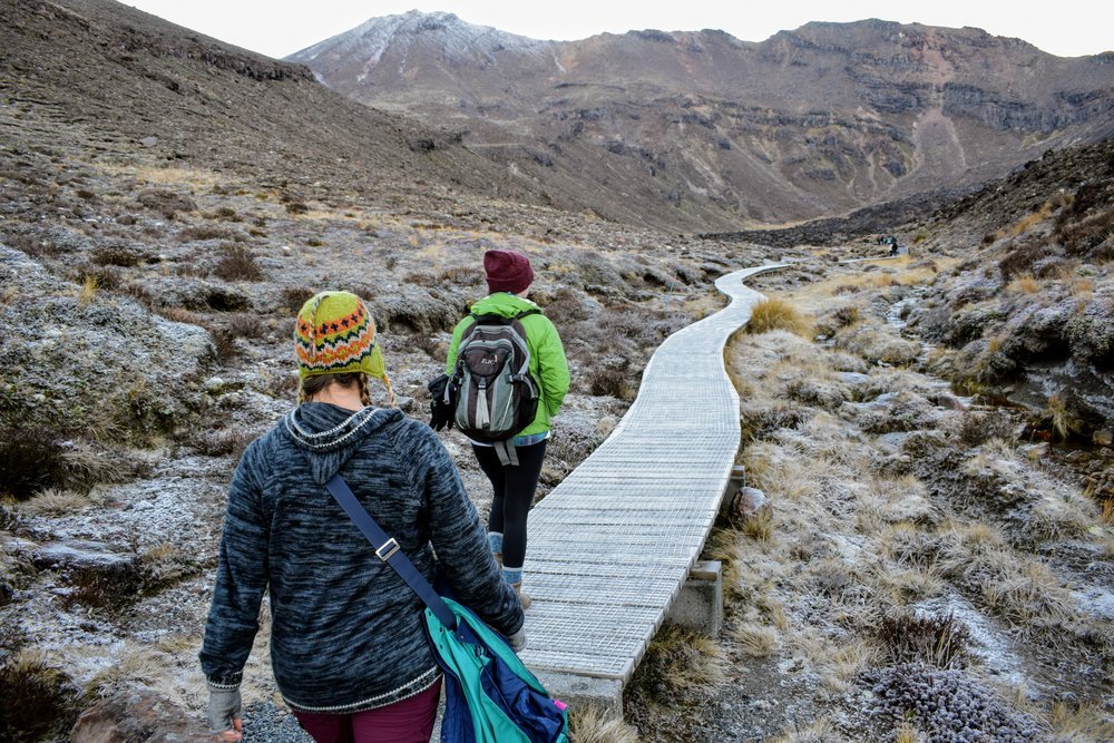
Luckily, as we approached Mangatepopo, the weather cleared and then (even better!) stayed that way for the rest of the day. The sun came over the horizon and we started the Crossing. The first part was deceptively easy and consisted of a well-maintained gravel trail and then boardwalk-style path as we got closer and closer to Mount Ngauruhoe. Also, if Mt. Ngauruhoe seems familiar to you, it’s because you may recognize it as Mount Doom from the Lord of the Rings film series.
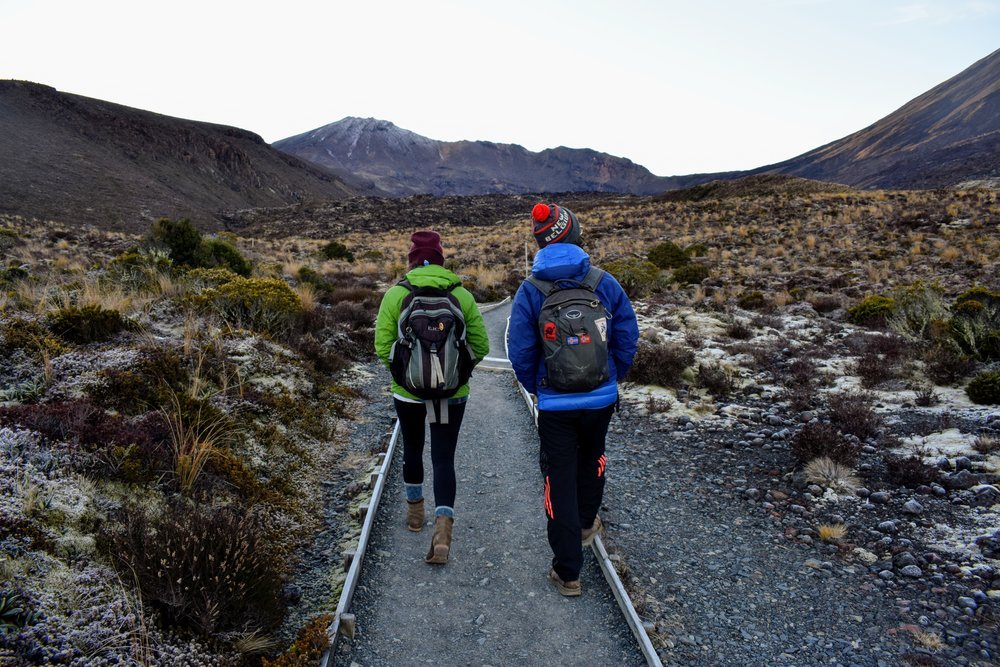
Emmett and CJ at the start of the trail, the easy bit,
The short boardwalk on the track before the approach to Soda Springs is deceptive: the track only increases greatly in difficulty from then onwards.
We crunched through the icy gravel and up a small incline before we found ourselves at the foot of Mount Ngauruhoe. It was an impressive volcanic cone topped with oxidized iron rocks that gave it a reddish hue. We could see a few miniscule figures loaded with gear making their way up the scree-covered mountainside to the crater. In the summertime, apparently it is possible to make the summit and return as part of a sidetrip from the actual Crossing. Since it was the end of June, aka the shortest days of the year, we reckoned we would not have enough daylight hours to try and do it all. But we certainly enjoyed seeing such a beautiful and dramatic volcano from all the angles below, as we walked on to the South Crater. Also, we were really delighted to find that the sky was clear enough that we could spot Mount Taranaki all the way over on the East Coast, halfway across the country from Ngauruhoe.
The path from Soda Springs to South Crater was one of the more treacherous bits of the Crossing. We had to climb up icy steps with hand chains pegged into the side of the adjacent rock. CJ later told us she had heard that bit was called “The Devils Staircase.” If it had been any icier or the visibility had been any worse, I can imagine that it would be incredibly challenging. Fortunately for us, it ultimately wasn’t even the most difficult part of the track.
The next bit of the journey took us up to the edge of the Red Crater, the very aptly named still-steaming crater that was one of many parts of Mount Tongariro. In fact, technically Mt. Ngauruhoe is part of the larger Mount Tongariro: it’s a parasitic cone. At the top of the Red Crater summit, a friendly DOC sign let us know that we were “halfway” through our hike. I say halfway because I think there estimates are for legitimate hikers because the next half of the crossing took us much longer than the projected time.
After a brief jaunt up the Red Crater’s edge (see above) we found ourselves facing an incredibly steep downhill slope covered in ash and tephra. This was definitely the hardest part of the Crossing, since it was impossible to get solid ground underfoot as you scooted down to the Central Crater of Mount Tongariro. Of the three of us, I in particular kept getting vertigo-like sensations because of the imposing nature of the descent. Have I mentioned before that I grew up somewhere incredibly flat? It’s not in my Florida-girl nature to feel comfortable on steep descents. So I just took my time trying to be as sure-footed as possible – potentially to the chagrin of mountain-siblings Emmett and CJ, though they graciously never mentioned it.
When I finally made my way to the bottom, I was rewarded with a fantastic view of the turquoise Emerald Lakes just off of Central Crater. Apparently, the lakes get their brilliant hue from minerals leeching out of the rocks below Red Crater. Whatever the case may be, they are pretty dang photogenic. I mean, just look at ’em:
After exploring the area around the ice-coated Emerald Lakes, we made the delightfully easy trek across Central Crater. This path was one of my favorite parts of the entire Crossing because the views (which had already been awesome) were the best of all. From across the Central Crater looking back, we could see not only each iconic peak of Tongariro National Park, but also an old lava flow from the Red Crater’s explosion.
From the end of Central Crater, we got one last alpine view: that of the acidic Blue Lake. Quick aside but – is it just me or does it seem like Kiwis love giving things obvious names? North Island, South Island, Blue Lake…? Anyway, it was a lovely light blue that paled (haha…ha) in comparison to the Emerald Lakes but was lovely nonetheless.
After Blue Lake, we got yet another lake view. We rounded a bend on the trail and found ourselves face-to-lake with Lake Taupo. Taupo is itself an old caldera from a supervolcano that erupted just this side of 30,000 years ago. In fact, the area underneath Taupo is still geothermically active as evidenced by fumaroles spewing steam around and across the lake.
The rest of the path is a hangry, frustrated blur, if I’m being honest. We took a zig-zag path down the hillside into native rain forest, which was quite unexpected. By then we’d seen all the different sights there were to see and kept thinking each turn might be the end but it never was. We still had at least an hour’s walk in the forest until we finally reached Ketetahi Car Park at the Crossing’s end. Add that to the fact that I had only had half a granola bar and a carrot to eat and you get a real grumpy gal. I think we were all pretty demolished by the hike by then because the three of us barely spoke. I just kept thinking that if I saw another set of gravel steps in the woods instead of a carpark, I would cry. I nearly did when the steps continued on… and on… and ON. Finally, we did make it.
My frustration was not relieved by finishing, though. I’m sure that Emmett and CJ would say the same. All day, we’d felt pressure to finish the Crossing by 4 PM when it began to get dark (that my friends, is one of the reasons we had an inadequate lunch). Not only that, but we also didn’t have a transportation plan. Our car was parked at the Mangatepopo Car Park nearly 30 kilometers away. Yes, you read that right: further away by road than the hike through the mountains that we’d just done. Emmett and I had previously had a lot of luck hitch-hiking in New Zealand so when we planned our Tongariro Alpine Crossing experience, we figured we could catch a ride with someone back to our car. When we got to the car park, though, we realized that this was not nearly as feasible an option as we had first supposed. First of all, hardly anyone else had a car parked at Ketetahi, as most people aren’t big cheapskates like we are and had splurged for a transport van from one of the many companies in the region offering such a service. Secondly, though we had finished with an hour till sunset, walking out from the car park to the main highway was going to take half an hour minimum. And then we’d be left to take our chances on a wintry remote highway in the dark. Yikes. We were all feelin’ a bit stressed until a very congenial dude with a truck gave the three of us a ride back to our car. Bullet dodged. Thank you hitching karma.
What to Know If You’re Considering Doing the Tongariro Alpine Crossing…
- Be prepared for weather changes!!!!
A) Consider adding a buffer of a few extra days in the area to your plan if you really want to do this track. I’ve heard of so many people who had to wait a bad patch of weather out until the Crossing is safe to undertake. It’s one of the reasons Emmett and I didn’t do it on our first visit to Taupo last year. We only stayed two days and the weather was abysmal.B) The track is 19.4 kilometers across alpine terrain. As you can see from my post above, we were incredibly fortunate to have excellent, clear weather on our hike. Also, if you can tell from our pictures: we really layered up on clothes. I personally started the day with a rain jacket, sweater, a hat, mittens, two pairs of pants, two pairs of socks, and sturdy boots. While I shed various items of clothing throughout the hike, I also ended up putting some back on as the sun began to lower in the sky. At a minimum bring a rain jacket, a hat, a warm base layer, and sturdy shoes (even in the summertime).
- Check the DOC Tongariro page for updates on weather and volcanic activity.
Often if it’s deep into the winter months of July, August, or even early September, DOC will recommend that you not even attempt to do the Crossing without a hired guide (approximately $195 NZD per person). Oh yeah, they also recommend CRAMPONS and ICE AXES. And there could be AVALANCHES. Yes, true winter on Tongariro is a whole ‘nother ballgame. Please, though, no matter what season you go, check out the DOC website to see if there are any warnings that apply to your hike. They also have even more practical recommendations on what to bring with you. - The track is definitely doable but Tongariro Alpine Crossing is not easy if you’re not particularly athletic. Emmett, CJ, and I are all in pretty good physical health but are not in shape. We all felt sore for nearly a week after the hike. And the next day? Phew. I definitely had shin splints and Emmett busted up his knee somehow. The DOC website says they estimate that the track will take between 5.5 or 7.5 hours. It took us about eight hours exactly, with lots of stops for picture-taking. But no lunch break.
- Bring plenty of food and water. We had enough water but not enough snacks/lunch, which was foolish and led to unnecessary hanger. Plus, if for some reason you get stuck and have to wait for a rescue ‘copter – you would probably want food & water in that scenario.
- Tell someone where you’re going!! Whether it’s a friend or family member back home or the staff at your accommodation, let someone know you’re attempting the Crossing so that they can call the rescue service if you don’t make it down the mountain before nightfall.
- I highly recommend doing the track in early winter, like we did. We were able to do the Crossing before any significant snowfall (so no paying for a guide or rental gear) but it was also low season so we didn’t have any of the insane crowds like I’ve seen in friends’ pictures.
- You should probably go ahead and pay for transport back to your vehicle with one of the numerous adventure companies around Taupo & the National Park. Unless, of course, you have friends who also have a car and you want to leave one at Ketetahi and take the other to Mangatepopo to start.
- If you want to experience all the stunning sights but don’t want to bother with figuring out the whole vehicle debacle, you could definitely hike to the Red Crater or even the Emerald Lakes and back to Mangatepopo and not feel as though you missed much. Nobody told me that the last hour (two in our case) is repetitive forest views. If I had a chance to go back, I’d also love to have enough time to summit Mount Ngauruhoe, so consider planning that into your Crossing.
- If you’re feeling especially adventurous, you could stay in either of the huts on the Crossing. Be sure to book ahead online as they can fill up fast. OR you could do the longer, multi-day Tongariro Northern Circuit trek and have a chance to see more of Mount Ruapehu and the National Park.

Fear can make smart people rush. For many owners, firearms for self-defense sit at the far end of the plan. A firearm rewards slow thinking and strict routines, whether you’re handling a basic handgun or maintaining rifle components like an AR-15 upper. No hype cycle.
This guide stays practical and direct. It explains how to check local rules before you buy or carry. It covers safe handling, secure storage, training, and post-incident steps. The goal is lawful use of a firearm for self-defense.
A Practical View of Personal Safety and Risk Reduction
Most safety wins happen before any physical conflict. Notice changes in tone, distance, and intent. Leave early when a situation turns unstable. Keep your words short and neutral.
At home, routines reduce surprises. Maintain locks, doors, and outdoor lighting. Keep walkways clear at night. Agree on a simple family plan for emergencies.
De-escalation is a skill you can train. Create space and move toward safer areas. Call for help early when danger feels real.
Start with Legal Compliance
Gun laws vary by state and locality. Rules can change across city lines and venues. Check the rules before you buy, transport, or carry. Recheck after travel or moves.
Start with what affects daily life. Confirm you can legally possess and purchase. Learn how your area treats vehicle transport and “loaded” status. Review carry limits, prohibited locations, and sign rules. Review storage duties in homes with minors or frequent visitors. A legal gun for self-defense matches those requirements every day.
Compliance checklist:
- Verify eligibility rules for your state and local area.
- Learn transport requirements for your vehicle and storage method.
- Review carry limits tied to your carry method.
- Map prohibited places on your common routes.
- Update your checklist after moves or travel.
Self-Defense Law Basics Without Legal Traps
Self-defense law is narrow and fact-driven. It rewards restraint and reasonable judgment. It punishes escalation after danger drops.
An imminent threat means the danger is happening now. Reasonable fear means the facts support your fear in that moment. Proportional response means your actions fit the threat. Defense of others can apply under the same limits.
Location can change expectations. Home rules can differ from public rules. Some places add duties tied to safe avoidance.
Permits and Licensing in Plain Language
Permits depend on location and carry method. Some areas require permits for concealed carry. Some venues stay off limits, even with paperwork.
If your area requires a self-defense gun license, confirm the requirement before carrying. Track renewals and keep documents organized. Keep a simple note of restricted locations you visit often. Update that note after any rule changes or travel plans.
“Without a License” Topics as a Compliance Warning
This topic attracts shortcuts and confident misinformation. People confuse one exception with a general rule.
Treat “no permit needed” claims as a warning label, not a plan. Local rules can limit carry type, transport method, and accessible storage. If you cannot explain the rule clearly, pause and verify it.
Do this first:
- Check permit rules tied to your carry method.
- Review vehicle transport requirements for your route.
- Identify prohibited locations you might enter.
- Learn how posted signs affect private property entry.
- Verify travel rules across county or state lines.
Firearm Safety Rules You Must Follow Every Time
Safety should feel boring and repeatable. Consistency prevents routine mistakes. These firearm safety rules protect you when stress narrows your attention. They also protect the people around you, including family members who may never touch the firearm.
Baseline handling rules:
- Treat every firearm as loaded.
- Keep the muzzle pointed in a safe direction.
- Keep your finger off the trigger until you are ready to fire.
- Know your target and what is beyond it.
Now build daily habits that prevent small errors from stacking up. Good gun safety rules include slowing down during cleaning, avoiding distractions, and securing the firearm before you shift tasks. Those habits matter most on busy days, when you feel rushed and confident.
Safe Storage and Responsible Access at Home
Safe storage prevents unauthorized access and reduces theft risk. Storage should match real life, not ideal life. Plan for children, teens, guests, roommates, and contractors.
Limit access to trained adults only. Keep the routine the same every day. This matters for guns for home defense, because the home includes more than you.
Home storage quick audit:
- Firearms stay locked when not in direct control.
- Keys and codes stay controlled by trained adults only.
- Ammunition stays secured and accounted for.
- Household rules cover guests and service visits.
- Storage gets reviewed after travel or schedule changes.
If you teach one concept at home, teach the rules of firearm safety in the same words each time. Consistency reduces misunderstandings and risky shortcuts.
Choosing a Firearm Responsibly for Home Protection
Selection should reduce error under stress. Reliability and simple operation matter. Choose something you can handle safely and store responsibly.
Pay attention to how a choice fits your household routine. Your storage plan and training schedule should guide the decision. Many owners buy home defense guns and never pressure-test their routines. That mismatch creates avoidable risk.
Be cautious with modifications that reduce reliability or add confusion. Keep the setup conservative and easy to operate.
Training that Reduces Mistakes and Legal Risk
Training builds safer reflexes and better judgment. Treat it as an ongoing routine, not a one-time event. Start with handling discipline and storage routines, then add decision-making under stress and calm communication.
Aim for consistency before speed. Practice stable muzzle control and clear stop points. Those habits matter as much as the gun for home defense you keep in the house.
Dry practice can help, yet it demands strict safety checks and full attention. Keep sessions short, focused, and free of distractions.
If a Defensive Incident Happens
A defensive incident becomes confusing fast. Prioritize safety first, then medical help, then communication. Call emergency services as soon as it is safe. Request medical help for anyone injured.
Provide basic facts and your location, then stop. Avoid speculation and dramatic explanations. Ask for legal counsel before making detailed statements. These steps support responsible ownership of self-defense guns after a crisis.
Common Mistakes that Create Legal and Safety Risk
Many cases go wrong after danger ends. People talk too much out of adrenaline. Others make avoidable compliance mistakes.
Common pitfalls include prohibited locations, improper vehicle transport, unsafe storage, intoxication, and brandishing. Escalation after insults can destroy a lawful claim. Remember, firearms safety rules apply at home and in transit, not only at the range.
Responsible Next Steps for Safe Ownership
Write down your rules. Review carry, transport, and prohibited locations, then recheck them after changes. Audit your storage and fix weak points. Schedule training and commit to a routine you can keep. If you keep a self-defense gun, write your household rules in plain language.

The constant worry over milk supply is extremely widespread, even with moms who are breastfeeding frequently and doing all the right things. As a mother, it is normal to think about is your baby is getting enough milk supplements. That is the reason why you are seeking products that boost milk supply supplements. These products help with lactation, yet it is important to understand their effects before including them in your routine.
Multiple lactation aid products are widespread in the market. There are herbals and scientifically made products available, and it might be overwhelming for you to choose which can actually help. Nevertheless, it is easy to get lost in the world of lactation aids, where numerous products can promise they are the final solution. It is important to know what ingredients are effective and how they help in your body to help you make an informed choice, which is safe and beneficial. This guide will take you through the kinds of supplements, the science of how they work, and the best practices of integrating them with your daily life.
What Are Boost Milk Supply Supplements
Galactagogues are also known as lactation supplements that are used to stimulate and increase milk production. Although others are pharmaceutical, they should be prescribed. Most of the parents use herbal or food-based supplements, which are available over the counter.
- Herbal Galactagogues
These supplements are plant-based, which are from plant extracts that have been used in ancient times by different cultures to assist nursing mothers.
- Nutritional Supplements
They are aimed at supplying large amounts of vitamins and minerals, including Vitamin D, Calcium, and Iron, which are all important to the overall health and energy of the parent who is breastfeeding.
- Food-Based Aids
There are foods that contain ingredients that help boost milk supplements.
You should keep in mind that these supplements are rather to enhance lactation, but not to substitute the biological needs of frequently feeding with milk by nursing or pumping.
Common Ingredients in Milk Supply Supplements
When you take a look at the ingredients of the popular boost milk supplements, you will see a repeated list of botanical ingredients.
- Fenugreek
This is probably the most familiar galactagogue. It is believed to trigger the production of sweat, as the mammary glands are modified sweat glands that can help the production of milk.
- Blessed Thistle
This is another herb that is known to provide benefits to your digestive system and helps in producing milk. It is often paired with Fenugreek.
- Fennel
Another kind of herb that has been known to have the properties of estrogen that increase the volume of milk and can be used to make more milk, and possibly to calm a colicky baby with its milk.
- Moringa (Malunggay)
A vitamin-rich, nutrient-packed so-called superfood that is considered to be especially popular in most cultures because of the high contents of iron and vitamins, which can significantly enhance the quantity of milk.
- Brewer’s Yeast
This contains vitamin B, chromium, and protein, which are the common ingredients in bread that help fight fatigue while breastfeeding.
How Boost Milk Supply Supplements Work
The hormones and the physical demand regulate the biological process of milk production. Supplements act in general through either one of the following mechanisms:
- Phytoestrogens
Herbs have hormone-like components that imitate the hormones that help stimulate the production of milk, and they are prolactin hormones.
- Improves Blood Circulation
There are certain ingredients that are mild vasodilators that enhance blood flow to the mammary tissues. An improved blood circulation makes the nutrients involved in the production of milk efficiently circulated.
- Nutritional Replacement
When you are breastfeeding, it is calorically and nutritionally demanding. Proteins and minerals are essential components that help the body to produce milk
- Stress Relaxation
Some ingredients, such as Chamomile or Lavender, which are also found in some lactation tea will make levels of cortisol drop.
Safety and Side Effects of Milk Supply Supplements
Even though the majority of herbal supplements pose no risk, natural does not necessarily imply that it is risk-free. It is essential to keep an eye on the reaction of your body and your baby to new additions.
It may also trigger allergic reactions. The allergic reactions of those allergic to legumes or to some plants. Since the supplements are not controlled like the drugs, the quality and dosage can be hardly similar across brands.
To be sure, the safest option is to consult the experts before taking any supplements. This is most especially advised to those moms who have health issues to avoid the worst-case scenario. In the instance of negative effects such as digestive discomfort, rash, loss of feeding comfort of your baby, discontinue use of the supplement and re-evaluate. The supply should always be followed by safety.
How to Choose the Right Boost Milk Supply Supplement
In choosing the right supplements, it is important to identify your needs first. In case of such problems as fatigue, it is better to select a supplement that contains additional vitamins and minerals.

- Examine the label: Find those products that indicate clearly all ingredients and specific doses. Do not use supplements that have proprietary blends.
- Search quality assurance: When the tests are done by a third party, and the manufacturing standards are clear, the product quality and safety level are higher.
- Read reviews carefully: The opinions of other moms who breastfed may prove handy, but remember that the outcomes are not the same among people.
- Prioritize Health Comfort: Too much stress can greatly affect your body, especially when you are a lactating mom. To manage this, you can do physical activities without feeling discomfort as long as you have a supportive garment like Momcozy cotton nursing bra that is breathable and will not limit your movements.
Tips for Using Milk Supply Supplements Effectively
The supplements are most effective as an addition to existing milk-boosting behaviors. Remember to be hydrated and consume protein, healthy fats, and complex carbohydrates.
Additionally, rest is important, and some moms neglect this. Even the use of supplements does not eliminate the fact that lack of sleep and stress may disrupt milk production. It is possible to make a significant difference by creating a comfortable feeding environment and putting on non-restrictive clothes.
Lastly, track changes gradually. Take at least a week or two of a supplement before making a decision on whether it is helpful, except when side effects manifest earlier. Never take many supplements together at the same time, it will just make it difficult to see which one is working.
Conclusion
Certain issues related to milk supplies are typical, and supplements are a good solution when applied properly. The combination of realistic expectations, safe ingredients, and strong breastfeeding habits is the best approach. The process is supported by supplements, whereas regular milk removal, nutrition, rest, and comfort are crucial in healthy lactation.
In life, you can determine whether a supplement is worth the ride or not by making the right decisions and listening to your body. The concept of support varies among all moms, and the correct tools with the right use will make you feel more secure and supported when feeding your baby.

Upgrade your workspace 🖥️ Experience ultimate comfort with our lightweight wireless ergonomic mouse 🖱️. Perfect for efficient, strain-free use! 👌
Ergonomic devices contribute significantly to comfort, productivity, and well-being in professional and personal settings. Properly designed equipment supports natural posture, reduces tension on muscles and joints, and allows users to perform tasks with greater efficiency. Among these devices, the computer mouse plays a key role, given the extensive interaction it requires during work, study, or gaming.
Focusing on ergonomic mouse products, such as the Razer lightweight wireless ergonomic mouse, the goal is to minimize discomfort, optimize posture, and enhance precision during prolonged computer use. Investing in a thoughtfully designed device helps reduce repetitive strain, increase control, and improve overall performance, whether for professional tasks or recreational activities.
Defining an Ergonomic Mouse
An ergonomic mouse is crafted to complement the natural shape and movement of the hand, aiming to reduce stress on the wrist and fingers. The design considers grip style, hand size, and user behavior to create a comfortable interface that promotes longer, pain-free usage.
When selecting an ergonomic mouse, several attributes contribute to performance and comfort. Consider grip style compatibility, device size, customizable buttons, adjustable sensitivity (DPI), wireless connectivity, and support for the wrist and palm. Focusing on these features supports both comfort and precise control.
The lightweight design allows effortless movement, reducing fatigue during extended sessions. Wireless connectivity removes cable restrictions, providing freedom of motion and a cleaner workspace. Together, these characteristics create an efficient and comfortable user experience suitable for office tasks, creative work, or gaming.
Advantages of a Lightweight Wireless Ergonomic Mouse
Using an ergonomic device delivers multiple benefits for comfort and productivity. Proper design reduces strain, supports healthier posture, and limits the risk of repetitive stress injuries. Users can maintain longer periods of focus, reducing interruptions caused by fatigue or discomfort.
A lightweight mouse provides superior maneuverability and agility, making it easier to perform delicate tasks or react quickly during gaming sessions. Its portability ensures that professionals or students can transport it easily between different workspaces without sacrificing usability.
Wireless operation simplifies setup, decreases workspace clutter, and allows greater flexibility in movement. Users can position the mouse freely and adjust the workspace according to preference. This freedom enhances efficiency and responsiveness, whether working on complex projects or engaging in interactive gaming experiences.
Overview of Leading Lightweight Wireless Ergonomic Mice
Several models currently stand out in the market for combining comfort, precision, and wireless freedom. High-quality options feature contoured shapes, adjustable DPI settings, responsive buttons, and durable construction. These mice cater to various hand sizes, grip styles, and activity types, offering solutions suitable for both work and play.
A comparative evaluation of available models examines features, performance, weight, wireless range, and user feedback. Some devices focus on professional ergonomics with long battery life and durable components, while others balance affordability with essential functions. This overview helps potential buyers make informed choices aligned with individual needs and preferences.
Ergonomic design and wireless functionality are key differentiators. A well-contoured shape reduces tension on the wrist and fingers, while a lightweight frame allows smooth gliding across surfaces. Wireless connectivity provides freedom from cords, contributing to a tidier workspace and effortless operation in various settings.

Selecting the Right Ergonomic Mouse
Choosing the best option involves analyzing personal requirements, hand size, grip style, and typical usage patterns. Sensor accuracy, DPI settings, button customization, and adjustability for comfort are all important aspects to examine.
Comfort and performance should be matched with intended use. Professionals who spend hours on spreadsheets or graphic design may prefer a larger, palm-supporting mouse, whereas gamers may benefit from faster response times and adjustable DPI settings for precision movements. User preferences regarding aesthetics, battery life, and portability can also influence the choice.
Durability and reliability contribute to long-term satisfaction. Quality devices are built to withstand repeated daily use, and wireless technology ensures consistent performance without interruptions. Rechargeable models or long-lasting batteries further support uninterrupted operation.
Maximizing Benefits
Using a lightweight wireless ergonomic mouse effectively requires attention to posture and workspace arrangement. Placing the mouse at a comfortable height, aligning the wrist naturally, and keeping the forearm relaxed all contribute to reducing strain. Frequent breaks and micro-stretches can maintain comfort during extended work sessions.
Customizing button functions and DPI settings helps tailor the mouse to individual workflows, improving efficiency in office applications or responsiveness in gaming. A clean workspace with adequate lighting supports visibility and reduces unnecessary tension, promoting smooth and precise movements.
Conclusion
A lightweight wireless ergonomic mouse combines comfort, mobility, and control, making it an ideal tool for professionals, students, and gamers. Thoughtful design alleviates strain on the wrist and fingers, promotes better posture, and allows extended use without discomfort. The absence of cords enhances workspace flexibility and movement freedom, while lightweight construction provides precise handling.
Selecting a model that aligns with personal needs and preferences can transform daily computer interactions, increasing productivity and reducing fatigue. Incorporating adjustable settings, responsive buttons, and ergonomic contours helps create a user-friendly experience suitable for varied tasks.
Using a well-designed mouse not only improves work efficiency but also contributes to long-term physical well-being. Its portability, wireless freedom, and comfort-focused design make it an excellent investment for anyone seeking an optimized computing experience.

Why Modern Homeowners are Moving Away from Manual Pool Maintenance

6 Best Movies for Travel Lovers